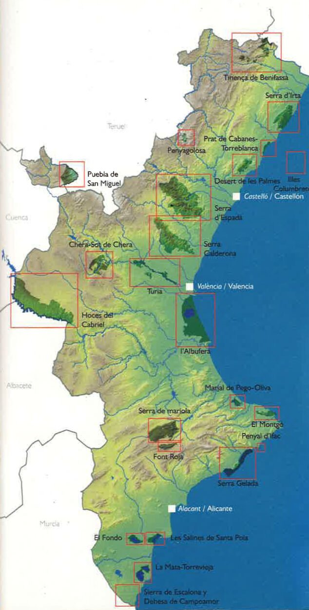
The Montgó is an extension of the Betic mountain ranges, the mountain system that runs through the south-southeast of the Iberian Peninsula. This mountain is one of its last vestiges before dying at sea and reappearing in the Balearic Islands: the Betic mountain ranges submerge with the end of Montgó and continue along the seabed to Ibiza and Formentera. The Montgó massif has always been a natural lighthouse for sailors, due to its height and its proximity to the sea. The importance of the Natural Park lies in the great wealth of flora and fauna that it houses in a very small area.
- 1.
- 2.
- 2.1.
- 3.
- 3.1.
- 3.2.
- 3.3.
- 3.4.
- 4.
- 4.1.
- 4.2.
- 5.
- 5.1.
- 5.2.
- 6.
- 6.1.
- 6.2.
- 6.3.
- 6.4.1.
- 6.4.2.
- 6.4.
- 6.5.1.
- 6.5.2.
- 6.5.3.
- 6.5.4.
- 6.5.5.
- 6.5.6.
- 7.
- 7.1.
- 7.2.
- 7.3.
- 7.4.
- 7.5.
- 7.6.
- 8.
- 8.1.
- 8.2.
- 9.
- 10.
General Information
Although in a strict sense the Montgó only affects Dénia and Xàbia, neighboring municipalities such as La Xara, Jesús Pobre, El Verger, Ondara, Pedreguer and Gata de Gorgos are dotted by their landscape footprint.

The Montgó completely marks the coastline of Dénia and Xàbia: the coast begins low in the Molinell (the border with the neighboring region to the north, La Safor), and continues sandy until Dénia. But in the southern part of the city, Les Rotes, the coast begins to be rocky. At Cabo de San Antonio the cliffs can already have 100 meters of vertical drop. Following the cape extends a plain known as Les Planes, which connects Dénia and Xàbia.

How to get
By the Mediterranean motorway AP-7, exit 62 (Ondara, Dénia, Jávea). Take the CV-725 road. At the height of La Xara we can take the CV-735 that leads to Jávea surrounding the Montgó to the south, or continue to Dénia. In Plaza Jaume I, take Montgó avenue on the rise, until Pare Pere Hermitage, starting point of some routes. The CV-736 road connects Dénia and Jávea, crossing the park in a north-south direction.
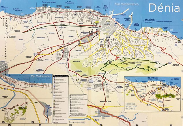
Location plan
This is a useful map to guide you: it will help you to recognize the urban area of the city, the urbanization areas, some neighboring municipalities and the location of the Montgó massif itself.
Most known points
These are the most named places that attract the most visitors within the Natural Park:
The Cova de l'Aigua
La Cova de l'Aigua o Cueva del Agua is on an almost vertical rocky wall in the shady area of Montgó. It is reached by a path located next to the Caseta del Pare Pere. There is a belief that this cave supplied water to Dénia in ancient times, but it is an unlikely fact. During the sixteenth and seventeenth centuries, refurbishment works were carried out on its interior, for the collection of rainwater, which through long mud pipes supplied an area of the hillside.
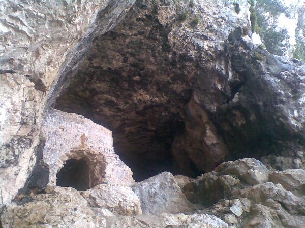
The Carved Cave
La Cova Tallada It is carved out of a cliff near Cape San Antonio. It is an artificial cave, the result of the action of man, who used it as a quarry for centuries to extract rough stone, so characteristic of the architecture of the Marina, especially Xàbia. It is accessed from a path that starts from the Torre del Gerro and skirts the coastline. The case of the Cova Tallada is exceptional, because it has Limited capacity between June 15 and September 30, to avoid the overcrowding of visitors. In order to enjoy it, you have to make a book. Access without it is prohibited.
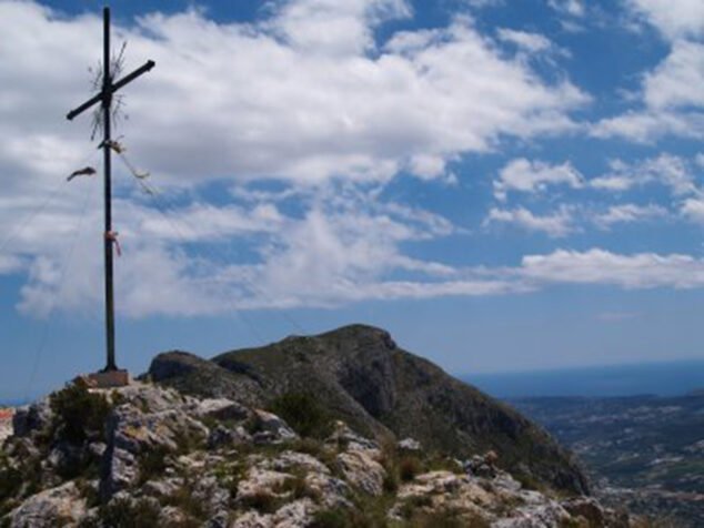
The Creueta
At the top of Montgó a cross stands, "La Creueta", a place much visited by hikers. It has a long history that you can know in your article in depth.
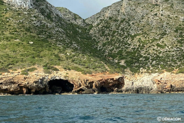
The Cabo de San Antonio Marine Reserve
It is a protected area of high ecological value, in which fishing and the collection of organisms, flora and fauna are prohibited. Diving is limited and requires a special permit; however it is a wonderful area to practice snorkel. On its seabed there are corals, posidonia meadows and other very valuable fauna and flora.
In addition, this marine environment of the Montgó Natural Park is ideal for whale watching and birdlifesuch as sea turtles, dolphins and whales. At the end of the Les Rotes area there is a cetacean and bird observatory with an explanatory panel.
Routes
The best way to enjoy the Montgó Natural Park is by coming into contact with it on foot or by bike. These are the marked routes:
Walking
- From the Camí de la Colònia to the Gamell cave, low difficulty
- Route from Cova de l'Aigua to Raco del Bou, of medium difficulty
- From Camí de la Colònia to the top of Les Planes, more difficult
- Route from the Camí de la Colònia to la Creueta: this is the most difficult
By bike
- From Camí de la Colònia to Cova del Gamell: easy route, which can also be done on foot
- Around the Montgó by bike passing through Dénia-La Xara-Jesús Pobre-Xàbia-Puerto de Xàbia
The Natural Park
The Montgó Natural Park has a extension of 2093'3517 hectares, that is, 20'93 km2: Dénia covers 12 km2, and Jávea 9 km2 of park. The maximum height It is 753 meters high.
The Visitor Center
The Montgó Natural Park headquarters are located in Dénia, in the Interpretation Center of the Montgó Natural Park, inside the farm of Bosc Diana: Camí de Sant Joan, 1. In this center there is an accessible exhibition with information on the ecosystems of Montgó and the Natural Reserve of the seabed of Cabo de San Antonio, the main routes, traditional uses and offers of activities for visitors . The exhibition has audio guides in 5 languages. If you need more information, the contact numbers are the 96 6467155 and 679196461. You can also write to email Park_montgo@gva.es. If you find it interesting, here is how to get there:
Who manages it and technical data
The Montgó Natural Park depends on the Ministry of Agriculture, Rural Development, Climate Emergency and Ecological Transition of the Generalitat Valenciana. This is the Official website of the Montgó Natural Park, in the portal of the Conselleria.
- Protection figure: Natural Park
- Date of creation of the Park: March 16, 1987
- Other figures: Place of Community Importance (LIC). Includes the micro-reserves of the flora of Les Rotes A, Les Rotes B, Les Rotes C, Cap de Sant Antoni, Cova de l'Aigua, Barranc de l'Emboixar and Illot de la Mona

Features
Geology and formation
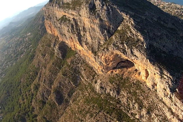
The Montgó figure is the product of the clash of forces between the African and European continental plates. As it is formed by limestone rock materials, within the natural park there are caves and chasms of origin karstic. The cliffs of the Cabo de San Antonio area undergo a continuous modeling with the action of the sea.
Climate
The Montgó is located in an area with a western Mediterranean climate, to which the entire Valencian territory belongs. But with the particularity that this is a transition zone between the more humid Mediterranean climate in the north and the more arid in the south. Average annual rainfall is around 700 mm, with a maximum between September and November. In this transition zone there is a set of reliefs, such as the Montgó, which act as a springboard for the winds coming from the northeast, which are the ones that bring the most intense storms. Rainfall increases in this sector and makes it the wettest in the Valencian territory.
At the summit of Montgó there is the phenomenon of crypto-precipitation: very abundant localized rains with the usual presence of cloudiness, as if the clouds were "hooked" as they passed over the top.
Flora
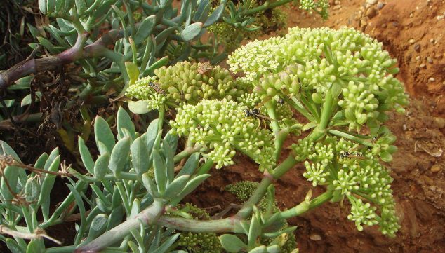
Almost 700 species of plants inhabit its small area, and many of them are endemic (this means they are only found here). The flora is very rich due to the geological and climatological peculiarities of the Montgó. Some of the most representative plant species are: the communities of sabina negra (Juniperus phoenicea) Of sea fennel (Crithmum maritime) and of marine juniper (Juniperus oxycedrus subsp. macrocarp).
Another very representative species is the Silene de Ifach (Silene Ifacensis). The always alive is endemicLimonium rigualii). The places where there are more endemic plants are also the most inaccessible, such as the cliffs of Cabo de San Antonio. A curiosity is that some of these endemisms are shared with the Balearic Islands: the silene d'Ifac, the marine juniper or the rock thistle (Cardunclus Dianius).
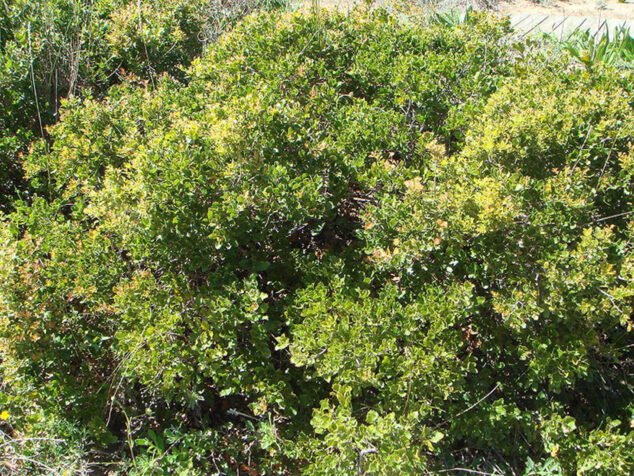
In the highest area of the Montgó dominate the rosemary (Rosmarinus officinalis) and also the ticklers (Quercus coccifera), which replace the overexploited holm oaks.
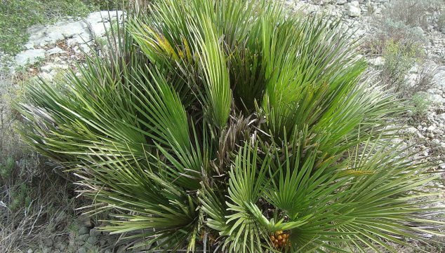
The pine trees in the park come from repopulation. In the shady and more humid areas there are communities of black juniper and heart of palm. The latter is the raw material for one of the most popular crafts of the Marina Alta, that of wicker, especially in Gata de Gorgos.
In shady areas there are also endemisms such as horseshoe grass (hippocrepis valentina). The flora of the park exceeds 600 species. The Montgó massif and Cabo de San Antonio have always had a good reputation among botanists. AJ Cavanilles, the Valencian botanist world-renowned eighteenth century, dedicates this text to Montgó in his work Natural History, Geography, Agriculture, Population and Fruits of the Reyno de Valencia (1797):
"Everything is green towards the north, except for the ravines and perpendicular cuts near the summit; on the contrary, towards noon everything is aridity and peeled rocks in almost horizontal banks, whose nature is limestone, in parts of ashen marble with some yellow, and others with limestone spar fragments. "
The botanist Cavanilles perfectly differentiates the sunny and shady areas that are so clear on the Montgó, with the great distinctions between the north and south faces.
What plants are in each area
These are landscape units that can be identified in the natural park, and the specific flora that grows in each of them:
- The cliffs of Cabo de San Antonio: only highly specialized plants are able to colonize a cliff. In the area corresponding to more or less 10 meters above sea level, where the splashes of the waves reach but is not subjected to their direct blow, are the sea fennel and the immortelle, adapted to live in cracks and withstand salinity. Further up there are Valencian horseshoe and col de peñas (Pseudocabiosa saxatilis), Sanguisorba ancystroids y SARCOCAPNOS SAETABENSIS. In the sections with less slope and in the small ravines, coscojar, romeral de garlanda, herradura valenciana and Centaurea Rouyi. And endemism Carduncellus dianus.
- The plain of Cape San Antonio: It is very altered by human action, with a lot of urbanization, fires, recreational areas ... There you can find kermes oak with garlanda romeral. In the romerales the rockroses are intermingled, among which the cistus monspeliensis. In the area near the lighthouse, repopulation has been carried out with halepo pines ( propagating through a pine forest (Pinus halepensis).).
- Slopes of Cape San Antonio: They do not have many differences in vegetation with respect to the plain, but it is necessary to emphasize its great masonry terraces, now abandoned. Precisely because of those ancient crops, scattered almond and carob trees are joined to kerosene and garlanda romeral.
- The northern slope of Montgó: especially kermesh-lentiscar with halepo pine. Romeral with garlanda, almond trees, carob trees. In the shadier areas, ferns and mosses, the selaginella denticulata. Canares of arundo donax and oleanders with blackberries. Valencian horseshoe and Teucrium flavum subsp. glaucum.
- Cliffs of the Umbria of Montgó: here the community of Valencian horseshoe and col de peñas, as well as juniper and palm hearts find their optimal environment. In this landscape, species develop that have adapted to the significant mists that deposit their crypto-precipitation here on a daily basis.
- Southern slope of Montgó (belonging to Xàbia): this landscape unit is mostly outside the park. There are kermes oaks and romerales de garlanda, without pines. In the areas with less slope there is a heart of rock (Hypericum ericoides) and mountain tea (glutinous Jasonia). Outside the park, rainfed crops (vine, almond, olive, carob) dominate.
- Cliffs of the sunny Montgó (also in Xàbia): they look like bare rock but there are interesting plant communities: black juniper, palm heart and also Chaenorrhinum crassifolium y Teucrium hyfacense.
- Summit area: it does not present great differences with respect to the slopes. The coscojar and the romeral dominate, also remains of old holm oaks. The greater height gives a cooler environment, which favors the presence of helianthemum croceum y Cavanillesii sideritis, rare on the slopes.
Botanical discoveries on the Montgó
These are some of the scientists who have been interested in this mountain over the years, and the plants they have discovered:
- AJ Cavanilles: Convolvulus valentinus, biscutella montana y scabiosa saxatilis.
- Ph.B. Webb: Cardunclus Dianius, a dianic-pitiusic endemism, and the Thymus webbianus.
- E.Boissier: hippocrepis valentina y Helianthemum cap-felis.
- At Cape San Antonio, CC Lacaita talks about Sonchus dianae y Silene hiphacensis.
- C. Pau speaks, among others, of the centaurea mongoi and poterium ancistroides.
- P. Font Quer describes the Dianic-Pitiusic endemism woodruff paui, which lives in the cracks in the rocks of Cabo de San Antonio.
Fauna
The Montgó is one of the most unique zoological natural sites on the Valencian coast. The best known animals are birds and mammals. Unfortunately, there are factors that negatively affect wildlife, such as urbanization in nearby areas. One of the most damaging cases, for example, is that of the Marquesa urbanization, in the municipality of Dénia. Other factors are fire, hunting, and hikers, although the latter is not a factor with much impact.
Mammals
In the bush lives the forest rabbit (Oryctolagus cuniculus), in the pine forest the common shrew (Russula crocidura), and the forest mouse (Apodemus sylvaticus). Also carnivores such as the genet (genetta genetta) and more sporadically the fox (Vulpes vulpes). In crops, rats and mice, dwarf shrew (Suncus Struscus), leporids and some mustelid like the weaselMustelia Nivalis). It is also important to mention the bat (Rhinolophus Euryhale), which lives in the caves and lower areas of the park.

In the marine areas of the Montgó Natural Park there are marine mammals such as the striped dolphin (Stenella coeruleoalba). The wealth of fauna of the marine environment is protected in the Marine Reserve of the Cap de Sant Antoni (Cabo de San Antonio).
Birds
Among the liarids or seagulls from Cabo de San Antonio, the most abundant is the herring gull (Larus argentatus).
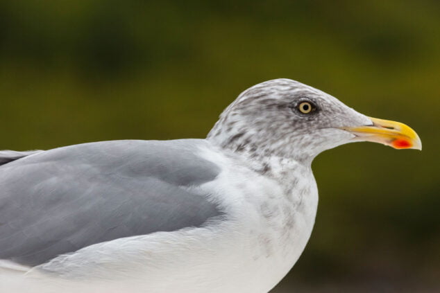
They are also very representative the yellow-legged gull (Laura Michaellis) and the shag (Phalacrocorax aristotelis, a highly threatened species of which the last colonies of the peninsular Mediterranean nest here. Other abundant birds in the Park are the barn owl (Tyto alba) and the common kestrel (Falco tinnunculus). Bonelli's eagle is also found (aquila fasciata), common hawk (Falco peregrinus) and eagle owl (vulture vulture).

But the most widespread birds are the passerines: in the rocks are the swifts (Apus sp.) and the rock plane (Pryonoporgne rupestris), and various turdid. In the bushes, finches, emberizids and sylvids, among which the Sardinian warbler stands out (sardinian sylvia). In the forest there are also sylvids like the striped wrenRegulus Ifniciapillus).
reptiles
You can see, among many other species, the common lizard (podarcis hispanica), long-tailed lizard (Pasammodromus algirus), the ocellated lizard or fardatxo in Valencianlacerta lepida), and the common geckos (Mauritanian Tarentola) and pink (Hemidactylus turcicus). Too snakes like the bastard snakeMalpolon monspessulanus), the horseshoe snake (coluber hippocrepis) and the water snake (Maura natrix).

Amphibians
Amphibians are scarce, because water is also scarce. But can be found common toad (Bufo bufo) and common frog (Perezi frog).
invertebrates
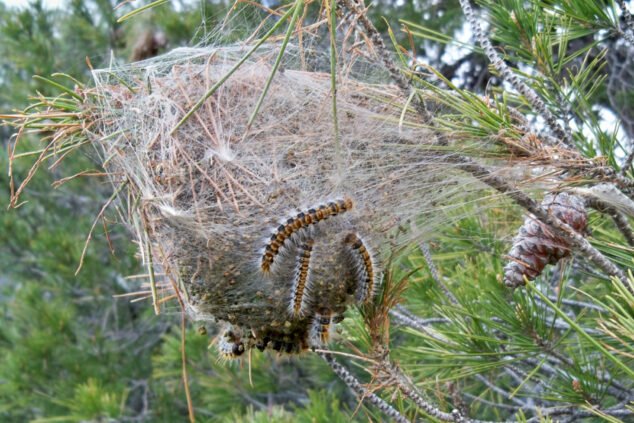
The helicids They are a family of terrestrial gastropods that includes most common snails. As for insects, on the Montgó there are Lepidoptera (of the families of satyrids, nymphalids, geometric y lost. There are a number of insects that can cause damage in wooded areas such as the dead pine leaf (Pini dendrolimus), The lycene Strymonidia esculi and the pine processionary Thaumetopeia pityocampa.
Highly protected species
Among the amphibians, the runner toad (calamite buffo), the spurred toad (Cultripes), and the spotted frog (Pelodytes punctatus). Of the reptiles, the pink gecko (Hemidactylus turcicus), the cinderella lizard (Psammodromus Hispanicus), the Iberian skink (I was deceived by the chalices) and the ladder snake (elaphe scalaris). Insectivorous birds such as the gardener bunting (hortulan emberiza), the lúgano (carduelis spinus), the dáuric swallow (daurica hirundo), the shrike (Lanius excubitor), the blackcap (Sylvia atricapilla) and sarda (sardinian sylvia), the climber (Tichodroma muraria), the red rocker (Monticola saxatilis), the royal redstart (Phoenicurus phoenicurus), the northern stonemason (Saxicola rubetra), and the white-capped cirlo (Turdus torquatus). Also diurnal raptors such as the peregrine falcon (Falco peregrinus) and Bonelli's eagle (Hieratus fasciatus), and nocturnal like the long-eared owl (The thing is), the eagle owl (vulture vulture), the short-toed eagle (circaetus gallicus), the common vulture (Gyps fulvus) and the black kite (milvus migrans). A very threatened mammal is the badger (Meles meles). The Moorish hedgehog is scarce (Erinaceus algirus) and the dwarf shrew (suncus etruscus). Also the robber bat (myotis myotis) and the cave bat (Miniopterus schreibersi).
History
The Montgó massif has had great importance as a watchtower over the Mediterranean throughout history. This is indicated by various findings.
Prehistory
The first archaeological evidence of settlers on the Montgó comes from the Cova del Montgó (Xàbia) and they are attributed to the Upper Paleolithic, about 30.000 years ago. The Cova del Montgó, also called cova ampla, is located about 450 meters above sea level on the southern slope of Montgó, and, as we have said, within the municipality of Xàbia.
It is accessed by a path that starts from the Dénia-Xàbia road in La Plana, along a path of about three kilometers. In this cave some recess points have been found that suggest that the cave was inhabited during the Upper Paleolithic, in the Solutrean. At the moment, these are the oldest testimonies of human presence on Montgó.
In 1989, members of the Gata Excursion Center discovered Cave paintings in the Cova del Barranc del Mig. The representations are small and have a symbolic character with geometric motifs that are difficult to interpret. The cave faces west, on the western slope of the Montgó. Its access is very difficult because it is located on an almost vertical wall, about 40 meters high. Neolithic burials, pottery vessels and arrowheads were also discovered there.
The iberos
The natural park houses the Iberian town of Alto de Benimaquia, where samples of commercial exchange with the Phoenicians have been found. L'Alt de Benimaquia It is 225 meters high, accessed from the Dénia to Xàbia road, kilometer 2. There is an angular fortification reinforced by towers.

Another important settlement is that of the Pic de l'Àguila: it is on the westernmost top of Montgó, and there are the remains of a fortification of three lines and domestic structures, which seem to form an urban structure. He Coll de Pous site It is on the northwestern slope of Montgó, a few meters from the Pic de l'Àguila site. There, Iberian ceramics were found with a high percentage of Italic imports, which suggests commercial links with Rome. This means that the city of Dianium was in the making. In this site, pieces from between V and II BC were found, coinciding chronologically with the Treasury of Montgó.
El Montgó treasure It was found in 1895 on the slope above the Coll de Pous. It consisted of 16 coins that were found inside a vessel, a set of 108-gram silver pieces and more than 1000 grams of bullion silver, probably the result of the Iberians' commercial relations. At present the whereabouts of this treasure is unknown.
Roman age
In Roman times, the Montgó massif was important as a point of reference to defend the important port of Dianium.
The Taifa of Dénia
Under Islamic domination, Dénia, capital of a Taifa, recovered its splendor as a port, and Montgó again, its importance as a watchman. The Arab Geographer Al-Sidrisi Abdul-Abdalla refers to him as Gebal-Kaun (Mont Caon, which will evolve to the current Montgó).
The Reconquest and later times
In 1244 Jaume I took the area, and the Hermitages of the Reconquest were built, which dot the slopes of Montgó. There are also windmills dating from the XNUMXth to the XNUMXth centuries. Starting in the XNUMXth century, the coasts of the Marina Alta suffered harassment from Berber pirates. To protect themselves, watchtowers such as the Torre del Gerro.

XNUMXth century: the agricultural colony of Montgó
La Montgó agricultural colony It was an agricultural colonization trial that did not give the expected results. To curb emigration, the State approved a law of Colonization and Inland Emigration (Law of August 30, 1907), by which land could be distributed to settlers who were willing to cultivate it. The City Council of Dénia had an area of land on the northern slopes (already within what is now a Natural Park) and decided to dedicate part to the cultivation of the vine for its fresh export, because the raisin was in crisis. He approved the project in 1921 and distributed these plots, which began to be called "Colònia del Montgó".

In 1925 most of the 51 three-hectare plots that had been distributed were cultivated and it seemed that the colonization had been a success. But in the following years, especially with the crisis of 29, grape exports fell and crops were abandoned. After a long period of inactivity, in 1953 this initiative tried to be reactivated: the land was re-parceled out and it was given back to settlers. But after a few years, they are uncultivated again.
In the early 70s, with the tree tourist, the land is revalued and the City claims them. At the end of 1976, the plenary session of the Dénia City Council approved the inclusion of the Colonia Agrícola del Montgó in the Inventory of Municipal Heritage.
Curiosities
Etymology: the origin of the name "Montgó"
According to the historian Roc Chabás, in a manuscript of 1856 that will later be published in his history of Dénia (1874), "(...) the word Mongó is derived from Mont Caon. There is no doubt that our mountain was called Caon in the XNUMXth century, as the famous Casiti affirms it when speaking of the book of Re rustica, which he says wrote an Arab author called Abd-el-Rahaman-Abu-Mathreph, in which he mainly deals of the plants that grow on the coast of Denia and on the slopes of Mount Caon or Mongon. The Nubian calls him Caun. In addition to being proven what this famous mountain was called before, we have in our favor the facility of becoming Mongó the words Mont Caon."
The anchoring
In Valencian rural areas, the term "terrace" is used, which means "terrace". The terraces or terraces are man-made formations that break down the slope of a mountain into steps, the horizontal part of which is used for cultivation. Each terrace is a step, and its function is to retain the land on the slope and facilitate agriculture. Within the limits of the Montgó Natural Park there have been two large groups of terraces: those that occupy the lower areas and those that are in the less accessible areas. The terraces of the Natural Park are in a wide strip that surrounds the massif at mid-height. Maintenance work on these terraces has not been carried out for a long time, and they are also eroded and deteriorated by fires and rains.
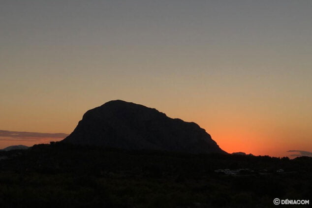
Photo Gallery
-
 View of the Montgó from the Castle of Dénia

-
View of Montgó on its slope of Dénia, with the moorings of the Nautical Club

-
The Montgó from Les Rotes beach

-
Clouds over the Montgó, in its dianense face

-
The Montgó skirt in Dénia

-
the-montgo-backlight
-
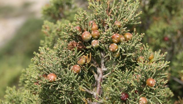
 Sabina negral (Juniperus phoenicea), Source: Wikipedia
-
Marine juniper (Juniperus oxycedrus subsp. Macrocarpa) Source: Wikipedia

Reference sources
Bibliography:
- "El Montgó and Penyal d'Ifac" Guides of the Natural Parks of the Valencian Community. Lift The Valencian Mercantile. Aneto Publicaciones SL. Text, cartography, coordination, design and layout: GradualMap SL.
- "Montgó Natural Park. Multidisciplinary study". Agència del Medi Ambient, Department of Public Administration. 1991. Various authors.
- Tourist Offices of Xàbia and Dénia


Loved reading this article about our magnificent Montgo! So many interesting facts and things to discover! Great article..thank you! ?